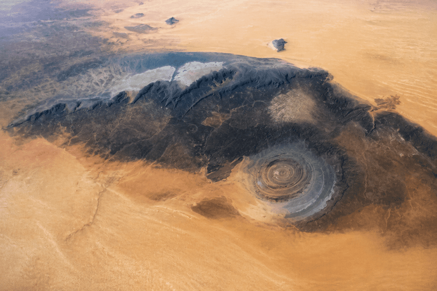
The Richat Structure, better known as the Eye of the Sahara, spans 25 miles across the Mauritanian desert. Seen from space, it looks like a bullseye etched into the sand. For decades, observers speculated it was an impact crater from a meteorite, but NASA’s satellite imaging has finally put that theory to rest.
It’s not a crater. It’s a geologic uplift.
The formation is actually a deeply eroded dome. Millions of years ago, molten rock pushed upward toward the Earth’s surface but failed to break through. This created a pressurized dome of sedimentary rock layers. Over time, erosion stripped away the top, exposing the concentric rings of igneous and sedimentary rock that give the formation its distinctive appearance.
Why does it look so perfect? The rings consist of different types of rock that erode at different rates. Resistant quartzites form the high ridges, while softer rocks wear away into valleys, creating the stark contrast visible from orbit.
Geologists have moved past the “meteorite” hypothesis because the structure lacks the telltale signs of an impact—there’s no evidence of shocked quartz or high-pressure mineral alterations that occur when a celestial body slams into the crust. Instead, the Eye is a testament to the slow, patient work of wind and water.
The structure sits in the Sahara, but it wasn’t always this dry. Paleoclimatic data suggests the region was once lush and wet, allowing water to carve the structure into the intricate, circular patterns we see today.
While researchers continue to study the site to understand the specific volcanic activity that pushed the dome upward, the consensus is clear. The Eye of the Sahara isn’t a scar from space; it’s a rare look at the Earth’s own internal pressure, laid bare by the relentless erosion of time.