Understanding the Phenomenon
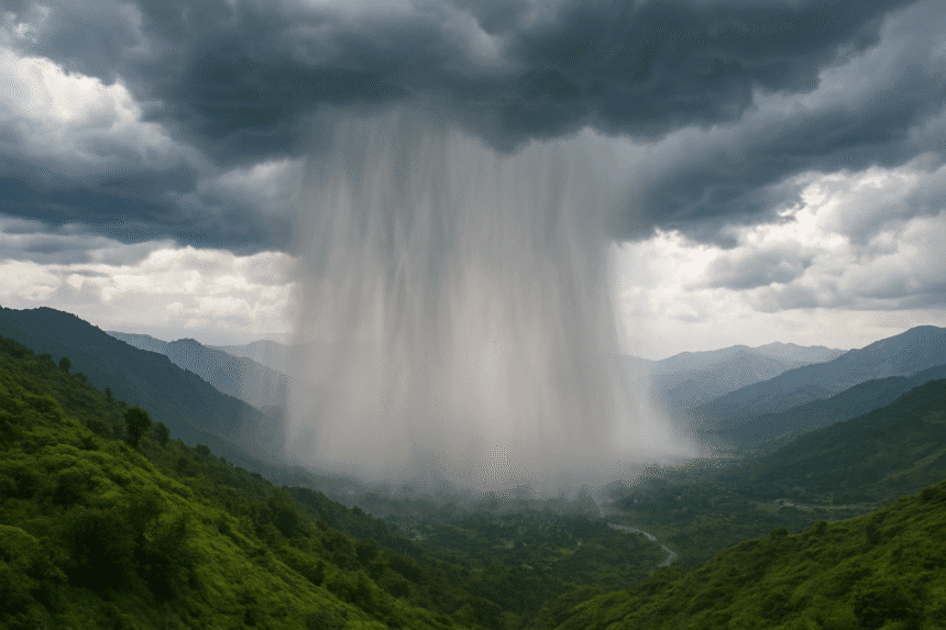
A cloudburst is not just heavy rainfall it is a violent weather event where the sky seems to open up all at once. In simple terms, it is an extremely intense downpour that can release more rain in an hour than what usually falls in an entire month. Unlike the slow and predictable rhythm of seasonal rains, a cloudburst strikes without warning, overwhelming everything in its path within minutes.
These events often occur in mountainous regions, where moist, warm winds collide with cooler air currents. This sudden clash forces storm clouds to burst, releasing an extraordinary amount of water over a small, localized area.
Cloudbursts Are More Dangerous than Ordinary Floods
Floods caused by rivers or seasonal rains usually allow some time for people to prepare alerts are issued, evacuations begin, and emergency measures take shape. Cloudbursts, however, do not offer such a luxury. They strike suddenly, creating flash floods, landslides, and urban chaos in the blink of an eye. Homes crumble, bridges collapse, and entire villages can be cut off within minutes.
The intensity and speed of a cloudburst make it much more destructive than regular flooding. Think of it as a “rain bomb” exploding over a community, unleashing a wall of water with devastating force.
Why Cloudbursts Are Becoming More Frequent
Until recently, cloudbursts were almost unheard of in Pakistan. Today, the word frequently appears in news headlines. Several key reasons explain this troubling rise:
- Climate Change: A warmer atmosphere traps more moisture, which means when it rains, it can pour with unimaginable intensity.
- Melting Glaciers: Rising global temperatures cause glaciers to melt faster, adding more water to rivers and streams. When combined with sudden rains, the impact is amplified.
- Urbanization and Deforestation: Natural landscapes that used to absorb rainwater have been replaced with concrete cities and barren lands, leaving water with nowhere to go except rushing into communities.
- Improved Monitoring: With advanced meteorological tools and constant media coverage, cloudbursts are being detected and reported more than ever before.
Why Pakistan Is at Greater Risk
Pakistan’s geography and climate make it especially vulnerable. The northern regions, including Gilgit-Baltistan and Azad Kashmir, are mountainous, fragile, and prone to cloudbursts. Small villages, weak infrastructure, and limited rescue facilities increase the risk.
At the same time, monsoon rains are already intense in Pakistan. When combined with melting glaciers, poor urban planning, and weak drainage systems in major cities like Islamabad, Lahore, and Karachi, the devastation becomes far worse.
From remote valleys to crowded cities, Pakistan’s terrain and development challenges make it one of the most disaster prone countries in the world.
Staying Safe and Prepared
While it is impossible to prevent cloudbursts, communities can reduce risks and damage through awareness and preparedness. Some essential steps include:
- Stay updated with weather forecasts during monsoon season.
- Avoid building houses near rivers, slopes, or flood channels.
- Keep a ready-to-use emergency kit with food, water, medicines, and flashlights.
- Move quickly to higher ground if rainfall suddenly intensifies.
- Encourage schools, mosques, and community centers to create safety and evacuation plans.
Preparedness does not eliminate danger but can save lives and minimize loss.
The Misuse of the Term “Cloudburst”
Experts warn that the word “cloudburst” is being overused in Pakistan’s media. Not every episode of heavy rain is a cloudburst. Mislabeling ordinary monsoon rains as cloudbursts creates unnecessary panic and dilutes the seriousness of real warnings.
Meteorologists explain that a true cloudburst is a rare event caused by orographic effects when moist air rises rapidly over mountains, triggering sudden and concentrated rainfall. In contrast, the widespread rains recently seen in Swat, Buner, and Chitral were intense but not technically cloudbursts.
Mahr Sahibzad Khan, Director General of the Pakistan Meteorological Department, emphasized:
“A cloudburst is very different from heavy rain. We issued early warnings before monsoon, including on June 23, but tragic events like Swat’s floods on June 27 still occurred despite repeated forecasts.”
This distinction is important because misunderstanding the phenomenon can lead to poor preparation and misguided responses.
The Bigger Climate Picture
The growing frequency of extreme weather events is a reminder of the impact of climate change on Asia’s monsoon system. Cloudbursts, once rare, are now becoming more common across India and Pakistan.
In recent weeks alone, these sudden downpours have triggered flash floods and landslides, claiming hundreds of lives. With more than 100 millimeters of rain often falling in just an hour over a small area, a cloudburst is not just a storm it is a natural disaster packed into a short burst of time.
It is quite literally, nature’s rain bomb a violent reminder that climate change is no longer a distant threat but a present day reality.